Author Archives: mshiva

Cities and Natural Environments

The City Is a Lie

From Ancient Egypt’s deltas to Edinburgh’s crags and peaks, the city pushes back against the dream of human separateness

By Sam Grinsell

Published by AEON

The ancient city of Alexandria lies on a narrow strip of Mediterranean coast to the west of the Nile delta. To the south is Lake Mariout, which once hemmed in the city rather closely, but has been reduced over the past century as land has been reclaimed for agriculture and for Alexandria International Airport. In 1921, during the period of British rule, a new masterplan was put in place for the city. It was prepared by William H McLean, a Scot who had an urban planning career across the colonial Middle East: he was town engineer in Khartoum, and also prepared a masterplan for Jerusalem. In his vision for Alexandria, McLean plotted its expansion to east and west, convinced that any land reclaimed from Lake Mariout would be needed for farming rather than housing. The fact that the city now straggles along the coast rather than sprawling inland is partly a result of this plan.

The other striking thing about the form of Alexandria is its two bays. The site of the city was, when Alexander the Great founded it in the 4th century BCE, one large bay with an island at its centre, called Pharos. In the 3rd century BCE, a road was built to the island. Over time, the Mediterranean has added to the original earthworks to such an extent that Pharos has become the head of a peninsula rather than an island. On each side of this peninsula are the two bays of Alexandria. Before the Nile was dammed in the 19th and 20th centuries, its annual flood dragged silt from the length of the river to the delta. Along the way, the silt deposited in the riverbanks and in the delta itself created some of the world’s most fertile soil. This process also expanded the delta into the sea each year, and the earth that was carried westwards by the waves of the Mediterranean to add to the land connecting Alexandria and Pharos was also part of this cycle. The watery land of the delta held such agricultural value because of this rich earth carried north by the river, and so the reason that the land around Lake Mariout was claimed for farming rather than urban growth is embedded in a complex set of land and water movements.

The Alexandria that you see on a map or satellite image today thus bears the long marks of actions by humans and nonhumans, its form emerging from centuries of collaboration between sea, land, river and people. But this is not generally how we imagine urban spaces.

The city is a lie that we tell ourselves. The crux of this lie is that we can separate human life from the environment, using concrete, glass, steel, maps, planning and infrastructure to forge a space apart. Disease, dirt, wild animals, wilderness, farmland and countryside are all imagined to be essentially outside, forbidden and excluded. This idea is maintained through the hiding of infrastructure, the zoning of space, the burying of rivers, the visualisation of new urban possibilities, even the stories we tell about cities. Whenever the outside pierces the city, the lie is exposed. When we see the environment reassert itself, the scales fall from our eyes.

Of course, cities are physically identifiable sites that are often clearly separated from the space around them. They might be surrounded by walls that define their limits, or green belts in which building is prohibited or heavily controlled. Even when large suburban districts surround the city, these often have separate governance systems. Nonetheless, all cities depend on a much wider territory beyond these boundary markers. Some or all of the following need to be brought in from outside to support an urban centre: food, water, building materials (wood, stone etc), workers, traders and their goods, raw production materials (wool, cotton etc), energy (in the form of material to be consumed, such as oil or coal, or on cables connected to a production centre such as a power plant or wind farm). This is the case irrespective of whether the city concerned has a clear physical edge or not.

Much debate about cities, at least in English-speaking cultures, reproduces the confrontations between Robert Moses and Jane Jacobs in the mid-20th century. Moses is portrayed as the archetypal planner, seeking to control New York’s urban scene through the built environment, pushing through highways in the face of opposition on the ground. Jacobs, meanwhile, is thought of as the champion of street life, arguing that ordinary people, given freedom to mingle in their daily lives, are best-placed to bring order to the city. This ongoing confrontation between top-down and bottom-up models of urbanism is central to contemporary urban thinking, but it leaves out the nonhuman. Both Jacobs and Moses view the city, fundamentally, as an entity made by people, the unfolding of a human vision. It is this underlying assumption that I wish to reconsider.

This is not to say that all 20th-century urban thinkers have been blind to the nonhuman. The philosopher Henri Lefebvre distinguished between urban spaces and urbanisation as a process; he foresaw a time when the latter would shape all modes of life at a planetary scale. The architectural historian Sigfried Giedion and the urbanist Lewis Mumford similarly saw essentially urban technologies conquering space and time. The literary scholar Raymond Williams traced the cultural separation between city and countryside. But all of this work has not succeeded in shifting the popular idea of the urban as human space, with a nonhuman outside. In fact, by claiming that urban processes or technologies might expand to dominate the rest of the world, some of these thinkers reinforce an imagined historical distinction between the city and nature.
More Here

A Display of Informal Architecture

A Display of Informal Architecture: New Documentary on the Ukrainian Makeshift Balconies Phenomenon

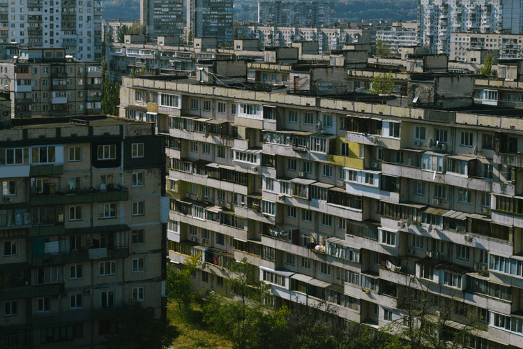
Taking advantage of a lack of governmental regulations, many Ukrainians turn to their balconies to compensate for the shortage of space in prefab-Soviet housing, rebuilding them in a variety of shapes and sizes. The short documentary Enter Through The Balcony explores this phenomenon in Ukrainian architecture, revealing a compelling image of post-Soviet history through local everyday life and culture.

In addition to showcasing a unique attitude towards private versus public space, the makeshift balconies phenomenon is also a symptom of the dramatic pendulum swing from mass uniformity and anonymity, to freedom of expression and ownership of private space, which shaped attitudes and architectures across the former Eastern bloc after 1991.

Across Central and Eastern Europe, the socialist political regime manifested itself architecturally through mass standardization, expansive collective housing estates, and a specific architectural expression, defined today as socialist modernism. The informal architecture that sparked around this type of architecture in Ukraine (as well as elsewhere) reflects the complicated relationship of the individuals with this architectural heritage, a symbol of an equally convoluted past. The Ukrainian makeshift balconies phenomenon also highlights the shortages of the housing schemes developed in the period between 1955 and 1991.

More Here

Informality and Social Embeddedness in Marshrutak Transport

Theorising informality and social embeddedness for the study of informal transport. Lessons from the marshrutka mobility phenomenon


By LelaRekhviashvili and WladimirSgibnev

Journal of Transport Geography

15 January 2019

Abstract

“This paper builds upon recent post-structuralist writings on informal economic practices, using most importantly a Polanyian institutionalist framework, to discuss formal/informal and market/non-market practices in the transport sector. The article proposes a critical reading of the literary canon of informal transport, which largely assumes a naturalness and omnipresence of markets. We illustrate how reductionist definitions of informal transport marginalise analytically important empirical detail, and furthermore, lead to misleading theoretical conclusions. In contrast, we analytically de-couple informality and markets, showing that formal and informal economic practices can be embedded in diverse social-cultural institutions. Such a theoretical framework allows for consistent evaluation and empirical examination of transport options, as substantiated by evidence from the marshrutka mobility phenomenon in Bishkek and Tbilisi. We observe marketisation, dis- or re-embedding, formalisation and informalisation as dynamic, inter-dependent and conflictual processes. On these grounds, the article argues for a critical re-appraisal of other forms of informal transport, old and emerging, both in the Global South and the Global North.”

Keywords

Informality
Social embeddedness
Marshrutka
Marketisation
Polanyi
Ride-sharing


Marshrutka Stories A Visual Archive

The Marshrutka Project
Marshrutka Stories A Visual Archive

“It is hard to study marshrutkas. ey are elusive; there are no clear criteria on what a marshrutka is or on what a marshrutka is not. They differ by color, size, and shape. They differ in whom they serve, who drives them, who owns them, who governs them. They differ in the ways they operate, the way routes are laid out, the way they are standardised. Rules of behaviour in a marshrutka also dier. They are quietly codified, not easy to comprehend, requiring familiarity and insiders’ knowledge. ey change, adjust, and adapt quickly. ey shrink and expand, they occupy public space but at points become invisible. ey simultaneously enable and confront. ey signify diverse, and at points contradictory, things for different people at different times. ey have been markers of the decay of Soviet infrastructure and of a Soviet vision of modernity. They have also signfied a new entrepreneurial spirit of capitalist modernity, of flexibility, freedom of choice, and the power of consumer demand. They have been demonized for being pre-modern, unruly, overcrowded and dangerous, while simultaneously representing locally divergent forms of solidarity, sociability, reciprocity, and sharing.”

Here

Tbilisi’s Rose Revolution Square

Tbilisi’s Rose Revolution Square: a Political Showcase

By TINATIN GURGENIDZE and SEBASTIAN WEBER

Published in FA – Failed Architecture

Georgia’s changing political orientation has been continuously reflected in the dynamics of its capital’s former Republic Square: from military parades, to soviet relics and a vertical refugee camp, to sanitised commercial functions.

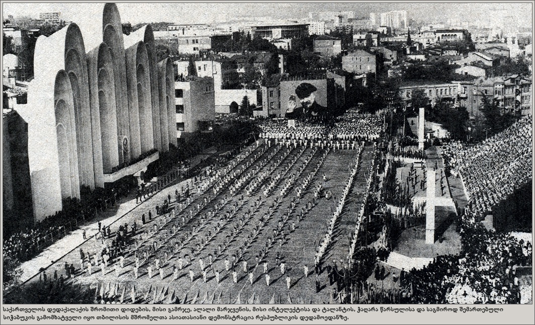
In the centre of Tbilisi lies the Rose Revolution Square, named after Georgia’s Rose Revolution of 2003. The place has changed a lot during the past decades, but still retained its character as an important part of the city. On the sunny 26th of May in 1995, the Georgian air force planes created a spectacle for the crowd that had gathered for Independence Day. Still called Republic Square back then, the square itself was also the setting for a military parade in celebration of the Georgia’s independence, which it gained shortly before the collapse of the Soviet Union in 1991. Although the air still contained the strange scent of war on that day in 1995 after a severe civil war, the young independent country was rejoicing. Yet, right in front of the audience stood the run-down Hotel Iveria, which was now home to over 800 Abkhazian refugees as a silent reminder of the recent conflicts. In fact, that very place had been a battlefield only a few years earlier.

Tbilisi’s Rose Revolution Square: a Political Showcase

Republic Square during a Soviet parade in the mid 1980s.

Almost two decades later, the square is mostly home to noisy traffic and vast empty spaces. The hotel has been emptied of the refugee squat, had a modern renovation and now belongs to the Radisson group. While the square is geographically exactly the same, a lot has changed. The place is not only one of Tbilisi’s few public squares, it is also arguably the place where the political and social transformation are most deeply reflected in urban space and architecture. Here, the country’s and the city’s recent past and present are visibly mixing, creating an absurd, mostly unused transitory space in the heart of town.

The story goes back to 1960´s, when Soviet Georgia was one of the top tourist destinations of the USSR. In 1967, the construction of the tallest building in Tbilisi was finished: Hotel Iveria, a 22 storey high structure designed by the Georgian architect Otar Kalandarishvili in the very geographical centre of Tbilisi and well visible from every point of the city. This prestigious Hotel was clearly not accessible to everyone. In order to book a room one had to make a reservation several months in advance through the official travel agency of the Soviet Union “Intourist”. Only the lucky ones would be able to stay in one of the rooms with a great view overlooking the entire town. Along with the hotel Mr. Kalandarishvili also designed the square in front of the hotel, which was finished much later, in 1983. As described by the architect himself at the time: “In the centre of the city, one of Tbilisi’s most important squares will be established by levelling an existing dip. The so created space underneath the square will contain more than 20 thousand square meters of useful space on three levels that will be used to create a social-cultural centre”.

More Here

Yerevan’s Architectural Fusion

“Yerevan is unlike any other Soviet city: an intoxicating blend of ancient and modern styles, grandiose planning and small-scale disorder and reminders of a nation’s tragic recent history

The first sights of Yerevan do not suggest a city planned or built with a great deal of care and consideration. Zvartnots Airport, named after a ruined cathedral nearby, is a circus of concrete and aluminium surrounds a derelict central control tower. From this building you can already infer two very important things about Armenian modern architecture: an appeal to the glorious past, combined with a flamboyant futurism and a tendency to neglect. The road from the airport, meanwhile, gives a completely false sense of what sort of a city (central) Yerevan is. Dusty, small houses and dozens of neon-lit improvised kiosks and gas stations, and behind them, the nondescript fortress of what was the largest US embassy in the world outside of Baghdad when it was built in 2005. It’s not here, as it might be in the Baltic, to keep an eye on Russia, but because of Armenia’s position on the borders of Iran and Turkey, and a short distance from Iraq and Syria. And then, quite abruptly, you’re in an absolutely exemplary, planned, and impeccably “European” city.

Yerevan offers the spectacle of an ancient city (it was founded as Erebuni in the eighth century BC — some fortress ruins are preserved in the suburbs) where almost everything you can see was built between the 1920s and 1980s. It also offers the spectacle of a Soviet city where the notion of a “national form” was deployed consistently from the very beginning. Some explanation of this can be found in the horrific events that immediately preceded its incorporation into the Soviet Union. In the 19th century, Armenia was divided between the Ottoman and Russian Empires; the assumption that Christian Armenians would sympathise with the Russians was the logic of the first genocide of the 20th century, the extermination in 1915 of over a million western Armenians by the Young Turk government. Refugees streamed into Yerevan — a small city which became briefly the capital of an fragile independent republic in the aftermath of 1917. The Bolsheviks, who had a large proportion of Armenian activists, eventually retook eastern Armenia in 1920, with the Red Army marching in without firing a shot. Within a couple of years, the Bolshevik government of Soviet Armenia commissioned Alexander Tamanyan — an exile from revolutionary Petersburg — to design a town plan for its capital.

The resulting plan is an icon of the city. You can find it on logos, as a relief in cafes, as an object of branding. It is not a 20th-century plan in any way: with its green Ringstrasse, and its radial spokes terminating in a vast opera house, it was more like the Hapsburg Empire reborn in the Soviet Caucasus. And as with a Hapsburg city, the result is exceptionally pleasant, logical and easy to understand. There is a rhetorical aspect to it, too. Many of the main streets lead up to slopes, from where you can get jaw-dropping views of Mount Ararat, the double-peaked mountain where Noah’s Ark ended up, its snowy top roaring up out of the clouds. Mount Ararat is, however, just over the border, in Turkey. The plan seems to have been deliberately executed to create a longing for the lost western parts of Armenia, and for the hundreds of thousands who were massacred there. It’s town planning as either memorial or irredentism, depending on what side of Ararat you’re on.”

More Here

Po-Mo in Soviet Tbilisi

Soviet Po-Mo:
What can we learn from Georgia’s forgotten master architect?

Jorbenadze’s Wedding Palace, Tbilisi, Georgia

Best known for his Wedding Palace, a gloriously phallic edifice which stands erect on a hill above Tbilisi, Viktor Jorbenadze was an outlier among late Soviet architects. Angela Wheeler and William Dunbar celebrate the work of an unsung postmodernist hero

Text by Angela Wheeler and  William Dunbar


Rising from the banks of the Mtkvari River, the structure dominates the landscape like an enormous abstract sculpture. Its ritual function is unmistakable: it is the size of a cathedral and clad in the same warm stone used in Georgia’s medieval churches. It also happens to be exuberantly phallic — a giant cock and balls against Tbilisi’s ancient skyline.The Palace of Rituals, or Wedding Palace as it is universally known, is the wrong building in the wrong place at the wrong time: a cathedral built in the atheist USSR, a Soviet celebration of Georgian national heritage, a cultural innovation in an era remembered largely for conformity. It is the work of Viktor Jorbenadze — nicknamed Jorbusier for his love of the French-Swiss master — an architect of genius whose daring and provocative buildings defy categorisation. Just like the now-forgotten moment that produced them.

Tbilisi from Safavid Persia to Postsocialism

The city of Tbilisi, current capital of the country of Georgia, experienced a turbulent set of changes at the dawn of the modern period, from little more than a mass of ruins in 1795 to the 19th-century political center of the Russian Caucasus to 20th-century capital of Georgia.  This project seeks to understand cities as intrinsically heterogeneous and historically layered objects: many places in one.  Cities are therefore intrinsically “multiple objects” inviting multiple readings.  Our website will treat Tbilisi as an “urban assemblage”, composed of heterogeneous networks of human and nonhuman elements and actors. From these heterogeneous materials and actors are assembled and stabilized “imagined cities”: the traditional “Middle Eastern” city, the divided city of colonialism, the modernist city of infrastructures, the socialist “cultured” city and postsocialist cities haunted by past and future.
To study such an intrinsically heterogeneous object is required an equally heterogeneous approach,  which renders objects as diverse as literary images of the city and material infrastructures comparable and commensurable within stable “urban assemblages”. Following the grant narrative, this website will divide Tbilisi into five such distinct periods: the maps will be linked to each period.

The City of Balconies: Tbilisi

The City of Balconies: elite politics and the changing semiotics of the post-socialist cityscape

Paul Manning

My first experience of Tbilisi was in the spring of 1992, a few short months after the coup that ousted the first post-socialist government of Zviad Gamsakhurdia. It also leveled much of a historic portion of the downtown area.  The general who had led the coup, Tengiz Kitovani, had been a sculptor in the socialist period.  As a result, the devastated downtown region became known jokingly at the time as ‘Kitovani’s exhibition’.
The coup against Gamsakhurdia was transformative in its effects on the Georgian city not only in the plastic arts, but also socially.  The emergent political divide between Anti- and Pro-Gamsakhurdia (‘Zviadist’) orientations often boiled down to the inherited cultural division between Tbiliseli ‘Tbilisian’ and provincial Georgian villagers.  The nationalist Gamsakhurdia government’s support was strongest amongst present or erstwhile Georgian villagers, whilst old urbanites, and the urban intelligentsia in particular, ranged themselves against the new government.
The 1992 coup was also a family feud within the socialist intelligentsia: A philologist-dissident-turned-president ousted by a sculptor-turned-general (Kitovani) and a criminal-turned-writer-turned-warlord (Jaba Ioseliani), the coup illustrated emergent and opposed tendencies within the socialist intelligentsia. Different self-conceptions of the urban intelligentsia were, as it were, incarnated in the figures who led this coup.  On the one hand, the coup, in which a sculptor-turned-general ousted a philologist-turned-president, illustrates a public, exoteric, battle over the self-definition of the intelligentsia, an essentially urban, elitist intelligentsia (represented by Kitovani) turning against a provincial or provincializing one (represented by Gamsakhurdia).  On the other hand, the presence of a unique ‘hybrid’, Jaba Ioseliani, a well-known criminal (‘thief of the law’, Georgian  k’anonieri kurdi, Russian vor v zakone) breaking the criminal laws of non-engagement with public political life, who was himself also a writer and intelligent turned paramilitary leader, gives the coup another hidden, esoteric dimension.  Here urban life and the intelligentsia is characterized not as a public apotheosis of national culture (dividing the intelligentsia from the people as urban to rural, but reuniting them within the framework of the nation), but as an urban bohemian subculture, stressing the opposition between the intelligentsia and the people, private urban subculture and public national culture.

More Here